Zhangye Travel Guide
Zhangye Facts
Chinese Name: 张掖 (zhāng yè)
Population: 1,233,800
Area: 38,600 square kilometers (14,904 square miles)
Location: in the west of Gansu Province, northwestern China
Administrative Division: 1 district (Ganzhou), 5 counties (Linze, Gaotai, Shandan, Minle, Sunan)
Area Code: 0936
Zip Code: 734000
GDP (2018): CNY 40.77 billion (USD 6.16 billion)
Highlights Colorful and Grand Danxia Landform
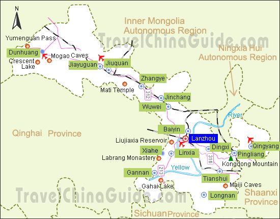
Zhangye is located in the west of Gansu Province and borders Wuwei and Jinchang on the east, Jiayuguan and Jiuquan on the west, Qinghai Province to the south and Inner Mongolia to the north. The colorful and grand Danxia landform at the Danxia National Geological Park is widely known by tourists from home and abroad. Hence it has become one of the top tourism destinations in China. Also, Zhangye shows diverse natural views varying from snow mountains to forests, grasslands, wetlands and deserts. In addition, with abundant rivers, sunshine and fertile land, Zhangye is the largest corn seed production area in China and an important production base of grain, vegetable, melon and fruit, etc.
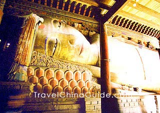
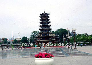
As an important commercial port on the ancient Silk Road, Zhangye has rich historic sites and amazing natural sceneries. The famous tourist attractions in the city include the Wooden Pagoda Temple, Danxia National Geological Park, Bell and Drum Tower, Shandan Buddha Temple and Shandan Horse Farm, and Giant Buddha Temple.
![]() Mountains: Mt. Qilian, Heli Mountain and Longshou Mountain
Mountains: Mt. Qilian, Heli Mountain and Longshou Mountain
![]() Rivers: Heihe River
Rivers: Heihe River
|
|
Recommended Tour
How to get to/around Zhangye
Weather
![]() Zhangye Climatic Features: continental climate with average sunlight of over 3,000 hours annually; coldest in January and hottest in July, and the comfortable time for travel is from June to September.
Zhangye Climatic Features: continental climate with average sunlight of over 3,000 hours annually; coldest in January and hottest in July, and the comfortable time for travel is from June to September.
Average Temperature: 7 °C annually
Rainfall: annual average rainfall 104 millimeters-459 millimeters (4 inches-18 inches)![]() When to Go: The best time to Zhangye is from June to September due to the easeful weather condition.
When to Go: The best time to Zhangye is from June to September due to the easeful weather condition.
Zhangye Travel Tips
![]() Physical Features: located in the area where the Qinghai-Tibet and Inner Mongolia Plateaus meet; borders the Mt. Qilian in the south, Heli Mountain and Longshou Mountain in the north; long and narrow climb in the shape of a running horse; the highest altitude in southeast reaches 5,564 meters (18,254 feet) and the lowest altitude in northwest is 1,284 meters (4,212 feet); the elevation of Zhangye is 1,474 meters (4,835 feet).
Physical Features: located in the area where the Qinghai-Tibet and Inner Mongolia Plateaus meet; borders the Mt. Qilian in the south, Heli Mountain and Longshou Mountain in the north; long and narrow climb in the shape of a running horse; the highest altitude in southeast reaches 5,564 meters (18,254 feet) and the lowest altitude in northwest is 1,284 meters (4,212 feet); the elevation of Zhangye is 1,474 meters (4,835 feet).![]() History: anciently named Ganzhou, it was a famous commercial port on the Silk Road and one of the biggest international trade markets in the country. Merchants from the west continuously arrived here for trading. Irrigation from the Black and Shandan rivers makes agriculture here quite well-developed. It has gained the reputation of "lush southern-type fields in the desert".
History: anciently named Ganzhou, it was a famous commercial port on the Silk Road and one of the biggest international trade markets in the country. Merchants from the west continuously arrived here for trading. Irrigation from the Black and Shandan rivers makes agriculture here quite well-developed. It has gained the reputation of "lush southern-type fields in the desert".![]() Special Local Products: Wujiang Rice, Zhang Wine made of local grapes, Xiaohe Chinese Dates, Mingle Garlic, Rapeseed, Huangsheng, Gaotai Capsicum, Paper Cuttings, local embroideries, cashmere
Special Local Products: Wujiang Rice, Zhang Wine made of local grapes, Xiaohe Chinese Dates, Mingle Garlic, Rapeseed, Huangsheng, Gaotai Capsicum, Paper Cuttings, local embroideries, cashmere![]() Local Highlights: Folk art performances taking place on traditional or religions festivals are popular, including walking on stilts, a boat that runs on land, the dragon dance, yangko, cantata and more.
Local Highlights: Folk art performances taking place on traditional or religions festivals are popular, including walking on stilts, a boat that runs on land, the dragon dance, yangko, cantata and more.
If by taxi, it costs around CNY 120 for the single trip.