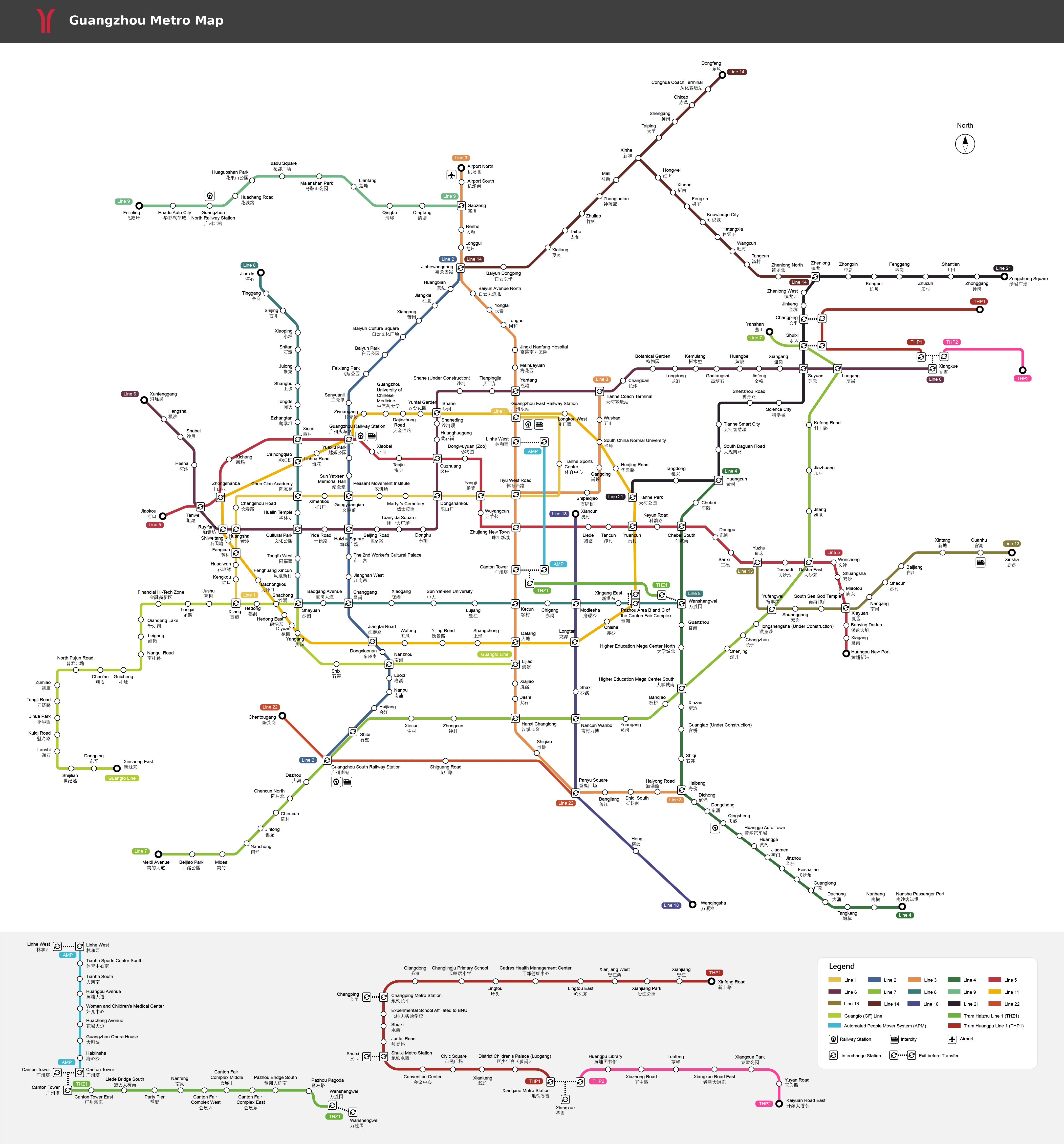
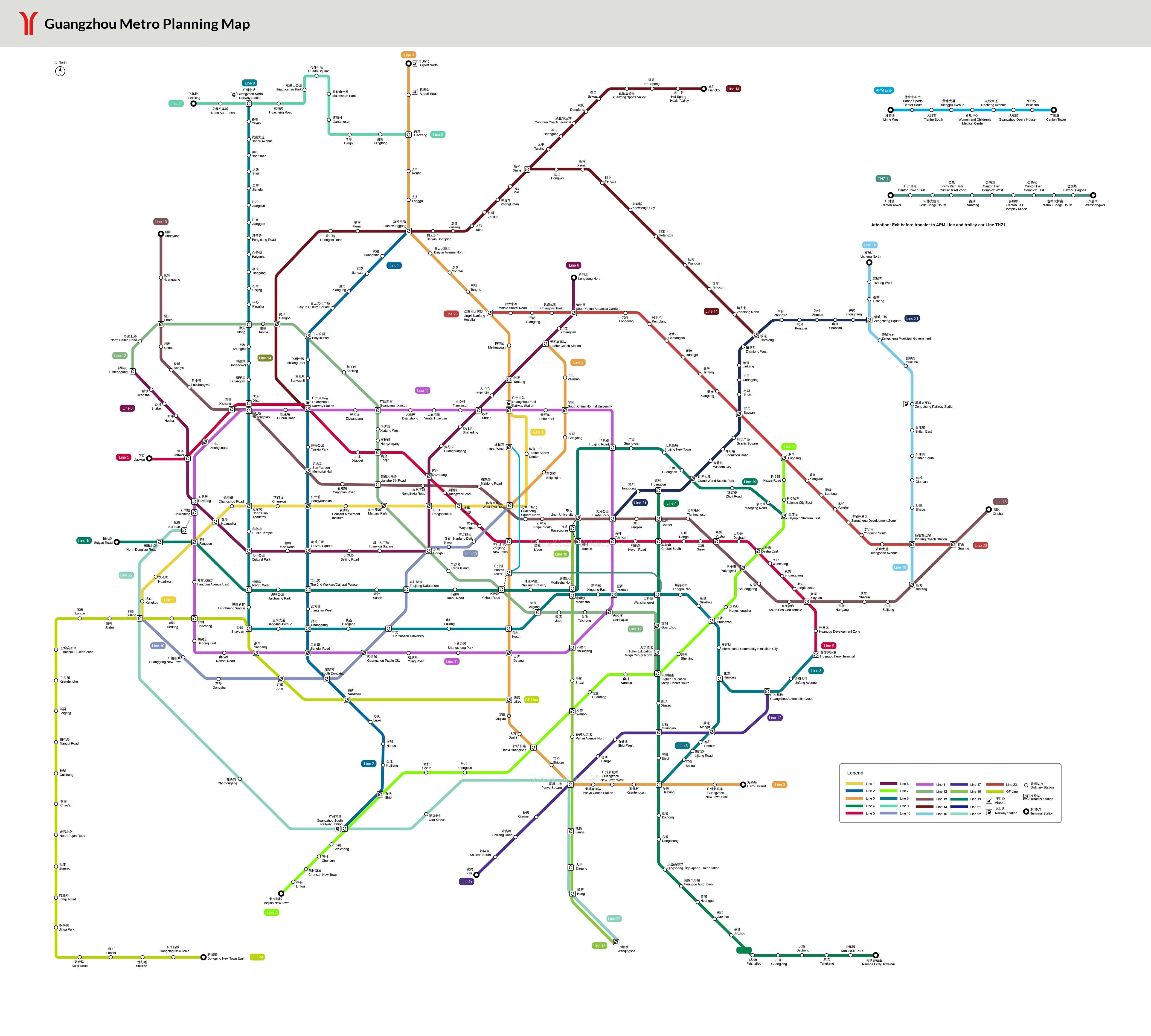
Guangzhou Metro Maps
Questions & Answers on Guangzhou Metro Maps
Asked by
Kuan from MALAYSIA | Apr. 15, 2024 21:29
 Reply
ReplyHotel
It's my first time to Guangzhou and I need to book a hotel for 4 night. Any advice on which area I should look for?
Answers (1)
Answered by
Keith | Apr. 16, 2024 02:42
Are you going to Guangzhou for travel? Then I advised to stay in Tianhe District due to its convenient public transportation to attractions like Canton Tower, the flourish streets, foods, shopping malls, starred hotels. ...
Asked by
Sky Porras from PHILIPPINES | Apr. 04, 2024 07:02
ReplyGuangzhou South Railway Station at 12AM
I am arriving at guangzhou south railway station at 11:30 PM on a tuesday. my hotel is at somerset bio-island.
Are subway or metro still available to that time?
Will taxi still be available at that time?
Thank you
Answers (1)
Answered by
Lori | Apr. 06, 2024 19:27
Metro is not available. Taxis are still operating.
Asked by
Rana from UAE | Apr. 03, 2024 01:48
ReplyBaiyun Airport to Yimi Hotel(Guangzhou Convention and Exhibition Center Canton Tower Branch)
Hello, I am travelling to China at the end of this month, My hotel is Yimi Hotel(Guangzhou Convention and Exhibition Center Canton Tower Branch)
Can you please guide me with a plan for Metro from airport to my hotel?
Also, can you guide me for the best Metro Plan from Hotel to Canton Fair?
Answers (1)
Answered by
Rita | Apr. 06, 2024 19:41
From the airport, take metro line 3 north extension to Tiyu West Rd., transfer to line 3 and get off at Kecun, take Exit D, walk eastward for 100m to catch bus 130, 250, 69, 184, 226, get off at 卷烟一厂. After, walk southward for 280m to find the hotel.
From the hotel, walk northward to take bus no. 226 to Zhuying (珠影), walk to Kecun metro station to take metro line 8, get off at Xingang East, then walk eastward to get there.
Asked by
Daljeet from CANADA | Mar. 25, 2024 13:59
Replyguangzhou airport to Dongguan.
Hello, What line should I take from Guangzhou Airport to Regal Palace Hotel at 1 Jiaju Avenue (Jiaju Dadao), Houjie Town, Dongguan, Guangdong, 523949
Please and Thank you
Answers (1)
Answered by
Marcy | Mar. 26, 2024 19:32
This journey takes 4 hours if you take the several metro lines and buses. I suggest take frequent Guangzhou North to Dongguan bullet train first, and then from Dongguan Railway Station, take Dongguan metro line 2 to Exhibition Center Station. This way takes 3 hours.
Asked by
Rafael from BRASIL | Mar. 22, 2024 11:41
ReplyI'm staying at the Paco Hotel Jinfeng Metro Guangzhou
I'm staying at the Paco Hotel Jinfeng Metro Guangzhou, how do I get from Guangzhou South Speed Rail Station to my hotel? Is there a metro, train or bus that allows me to get to my hotel?
Answers (1)
Answered by
Lori | Mar. 25, 2024 02:08
You can take metro line 7 to Luogang and transfer to line 6 to Jinfeng, take Exit C and walk southward to find the hotel.