Huangnan Travel Guide
Huangnan Facts
Chinese Name: 黄南藏族自治州 (huáng nán zàng zú zì zhì zhōu)
Population: 276,800
Area: 18,800 square kilometers (7,259 square miles)
Location: in the southeast of Qinghai Province, northwest China
Administrative Division: 3 counties (Tongren, Jianzha, Zeku); 1 autonomous county (Henan Mongol Autonomous County)
Area Code: 0973
Zip Code: 811300
GDP (2018): CNY 8.833 billion (USD 1.335 billion)
Nationalities: Tibetan, Mongolian, Han, Hui
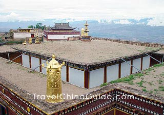
Hometown of the Tibetan Regong Art
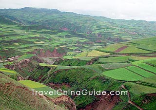
Huangnan Tibetan Autonomous Prefecture is seated in the southeast region of Qinghai Province, neighboring Haidong to the northeast, Hainan to the northwest and Golog to the southwest. It also shares a boundary with Gansu to the southeast. Huangnan's ethnic art is amazing. Regong Art in Tongren County is an important school of Tibetan Buddhist art in China. It is divided into painting (Thangka, mural), barbola and sculpture (woodcarving, clay sculpture, stone carving), covering a wide range of subjects including Tibetan Buddhism, politics, economy, history, folklore, literature and art. Their works feature vivid shapes, fine brushwork, bright colors and unique layouts. There are many shops selling Thangka paintings which are portable and exquisite travel gifts. Kanbula National Forest Park Fairy Cave and Aqiongnanzong Temple are hot scenic spots in Huangnan.
|
|
Huangnan Attractions - Things to Do
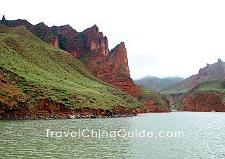
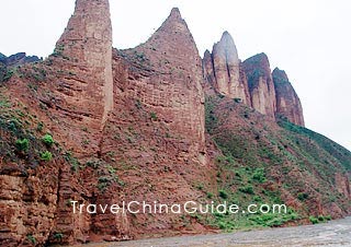
Kanbula National Forest Park
Being the first national geo-park in Qinghai, Kanbula National Forest Park is a scenic area with Danxia Landform as the main sight. It is adjacent to the Yellow River in the north and close to the magnificent Lijiaxia Hydropower Station. The red mountains in Kanbula and the green lake in Lijiaxia Reservoir set off perfectly with each other, forming a beautiful natural painting.
| Fees: | Entrance Ticket: CNY50 |
| Transportation: | Take long distance bus from Xining Long Distance Bus Station to Kanbula (Lijiaxia) Town. It costs around CNY 23. |
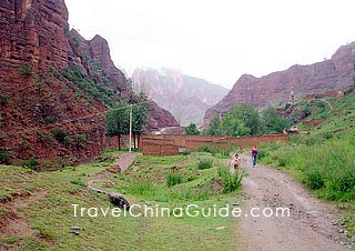
Fairy Cave
There is a grand natural limestone cave in Henan County, called Fairy (Xiannv) Cave, which is enigmatic and deep. Inside the cave, there are magnificent halls, mysterious underground lakes and pools.
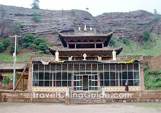
Aqiongnanzong Temple
Aqiongnanzong Temple is the largest nunnery of Rñin-ma-pa (Ningma or Red) sect of Tibetan Buddhism with more than 1,100 years of history. Another influential Buddhist site is Longwu Temple which belongs to Buddhist architecture of Gelug (Gelu) Sect of Tibetan Buddhism.
|
|
How to Get to Huangnan
The only means to travel around Huangnan Prefecture is by bus. Anchored by the county seats of each county, the transportation is not troublesome because noted scenic spots are all not far away from these county towns. Highways connect the prefecture with Xining, the capital city of Qinghai Province, Xiahe county, and Linxia Hui Autonomous Prefecture in southern Gansu. Xining is about 181 kilometers (112 miles) from Huangnan, about four hours drive.
|
|
Weather
Huangnan Prefecture enjoys a continental plateau climate with clear dry and wet seasons, long, chilly and dry winter and short, refreshing and humid summer. The annual average temperature of Huangnan weather range of the whole prefecture is around -0.9℃ to 8.5℃ (30.4℉ to 47.3℉). July to September is the best period to visit Huangnan Prefecture.
Huangnan Travel Tips
![]() History: Before the Western Han Dynasty (206BC-24AD) conquered it in 61BC, Huangnan region was inhabited by the Qiang people, an ancient tribe in western China. One year after the subjection, Heguan County was established there. It was once the domain of Tubo regime in Tibet during the Tang Dynasty (618-907). Huangnan Tibetan Autonomous Prefecture was established in 1955.
History: Before the Western Han Dynasty (206BC-24AD) conquered it in 61BC, Huangnan region was inhabited by the Qiang people, an ancient tribe in western China. One year after the subjection, Heguan County was established there. It was once the domain of Tubo regime in Tibet during the Tang Dynasty (618-907). Huangnan Tibetan Autonomous Prefecture was established in 1955.
Thanks in advance.
2. From Xiahe to Tongren: The departure time is 07:30. The ticket fare is CNY 32 per person. About the return way, I remember that the schedules is still at 07:30. It costs CNY 41 per person.
Hope helpful!