Haibei Travel Guide
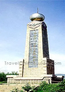 |
| Monument of First A-bomb Research Base, Xihai Town |
Haibei Facts
Chinese Name: 海北藏族自治州 (haǐ běi zàng zú zì zhì zhōu)
Population: 284,300
Area: 34,068.4 square kilometers (13,153.9 square miles)
Location: in the northeast of Qinghai Province, northwest China
Administrative Division: 3 counties (Haiyan, Qilian, Gangcha); 1 autonomous County (Menyuan Hui Autonomous County)
Area Code: 0975
Zip Code: 814000
GDP (2018): CNY 8.353 billion (USD 1.262 billion)
Nationalities: Han, Hui, Tibetan, Mongolian, Tu
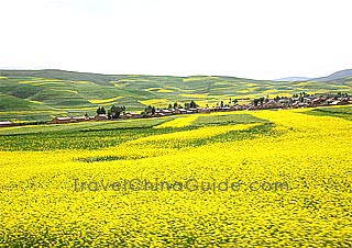
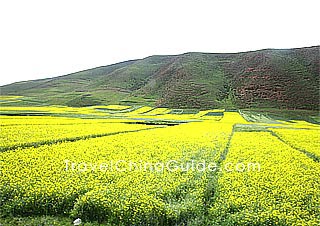
Famous for Vast Rapeseed Flower Sea
Located in northeastern Qinghai Province, Haibei Tibetan Autonomous Prefecture borders Xining and Haidong to the southeast, Haixi to the west and is separated by the Qinghai Lake from Hainan in the south. It also shares a boundary with Gansu Province to the northeast. Haibei's tourism resources are rich and diverse, which mainly concentrated in Haiyan, Gangcha, Qilian, Menyuan counties. This city highlights a vast rapeseed flower sea, Xianmi National Forest Park, Heihe Canyon with shinning glaciers falling from mountains, beautiful Jinyintan Prairie, Qilian Mountain Grassland and snow mountains. The golden rapeseed flowers in Menyuan County extend for several tens of kilometers along the Haomen River, forming a grand and impressive view against the blue sky and Qilian Mountain. July is the best time to see rapeseed flowers.
Haibei Attractions - Things to Do
At present, the scenic spot has been equipped with some recreational facilities and sports sestablishments. Visitors can take a yacht to Haixin Island in south-central Qinghai Lake to admire the green and elegant scenery and ancient temple in the mountain or to overlook the lake from the top of the Haixin Hill. Menyuan County is a main production of oil plants. Mid-June is the season of rape flowering. The rape fields stretch far to the horizon, like golden wave rolling in a golden sea. Xianmi National Forest Park is the largest virgin forest zone of Qinghai Province, being the source of many inland rivers.
|
|
The Shadao Island and Haixin Hill
These are all well known attractions of Qinghai Lake in southern Haibei Prefecture. Like a crescent floating on eastern Qinghai Lake, Shadao Island is formed by sand blown by wind. It is connected with the dunes on the east bank of the lake.
Xihai Town
As the seat of prefecture government, it was the locality where the first A-bomb and H-bomb were born. Therefore the town is spoken of as the 'Atomic City'. Some remains are still there for show.
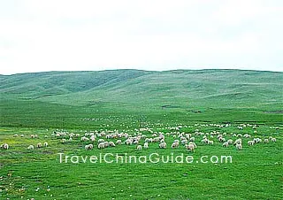
Jinyintan Prairie
It neighbors Qinghai Lake in the west. It is a typical Tibetan pasturing area, whose best tourist season is July to September.
|
|

How to Get to Haibei
Qinghai-Tibet Railway runs through the lake shore area of Haiyan and Gangcha counties of southern Haibei. Qinghai-Xinjiang Expressway and National Highway No.315 pass across the south region of this Prefecture. There are also National Highway No.227 and two provincial highways in northern Haibei, but the road conditions are not so good. In addition, the road around Qinghai Lake is also open. Xihai Town is about 100 kilometers (62 miles) from Xining, the capital city of Qinghai. Visitors can first get to Xining by air and head for Haibei by train or bus. Taxi and motorbike are the main means of transportation inside the town.
Weather
The prefecture enjoys a continental plateau climate with the annual average temperature of -0.3℃ to 0.7℃ (31.5℉ to 33.3℉), and most of the region has its annual average temperature below 0℃ (32℉). Haibei weather has rich sunshine, but rainfall only drops densely in July and August. Summer is the best season to visit this Prefecture.
Haibei Travel Tips
 |
| Haibei Tibetan Autonomous Prefecture |
![]() History: Haibei was the home area of the Qiang, an ancient group who were the forebears of the later Tibetans. In 120BC, the Han (206BC-220AD Troop entered this area and the Qiang people moved to the foot of Qilian Mountains. Administrative bodies began to be established here in the year 4AD. The Haibei Tibetan Autonomous Region was founded in 1953 and renamed as the Haibei Tibetan Autonomous Prefecture in 1995.
History: Haibei was the home area of the Qiang, an ancient group who were the forebears of the later Tibetans. In 120BC, the Han (206BC-220AD Troop entered this area and the Qiang people moved to the foot of Qilian Mountains. Administrative bodies began to be established here in the year 4AD. The Haibei Tibetan Autonomous Region was founded in 1953 and renamed as the Haibei Tibetan Autonomous Prefecture in 1995.
Is it possible to book a day trip to here from the Qinghai lake area, Xining, Menyuan or Zhengye?
I haven't seen any hotels online, it's hard to find any information.