- 2 Days Best Chengdu
- 2 Days to Leshan & Emei
- 1 Day Panda Tours
- 5 Days Chengdu to Jiuzhaigou
- 6 Days Chengdu Lhasa
Top Chengdu Attractions
More Things to Do
- Leshan Giant Buddha
- Mt. Emei
- Dujiangyan Irrigation System
- Sichuan Cuisine Museum
- Jiuzhaigou Scenic Area
- Huanglong Scenic Area
- Sichuan Opera
Top 10 City Tours
Code: BC-CD01
Spectacular Round-Sichuan Riding Experience
Itinerary: 10 Days of Chengdu - Dujiangyan - Yingxiu Town - Wolong Town - Rilong Town - Mt. Siguniangshan - Xiaojin County - Danba County - Bamei Town - Xinduqiao Town - Kangding County - Luding County - Moxi (Hailuogou) - Luding County - Ya'an - Chengdu
This long bicycle journey, spanning from the flat Chengdu Plain to the Qinghai-Tibet Plateau, is full of breathtaking landscapes. Along the way, you will also pass a multitude of minority villages, where you could learn about different minority cultures. It won't be easy, but you will definitely feel worthwhile after the journey.
This long bicycle journey, spanning from the flat Chengdu Plain to the Qinghai-Tibet Plateau, is full of breathtaking landscapes. Along the way, you will also pass a multitude of minority villages, where you could learn about different minority cultures. It won't be easy, but you will definitely feel worthwhile after the journey.
Day 1 Chengdu - Dujiangyan
Itinerary: The first destination will be Dujiangyan City. Today, you will set off from Chengdu and ride northwest along the Lanmo highway for around 69 kilometers (43 miles) to Dujiangyan City. Upon arrival, you can find a hotel to stay overnight.
Suggested riding time: 10:00 - 16:30, 6.5 hours
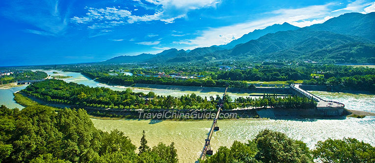
Friendly Tip: Dujiangyan is the world's oldest and only surviving water conservancy project characterized by no dam diversion. The scenery around is amazing with numerous cultural relics. If you're interested, you can set off earlier and pay a visit upon arrival, or stay 1 more night here to take a one-day tour to Dujiangyan scenic area and Mt. Qingcheng.
Suggested riding time: 10:00 - 16:30, 6.5 hours
Friendly Tip: Dujiangyan is the world's oldest and only surviving water conservancy project characterized by no dam diversion. The scenery around is amazing with numerous cultural relics. If you're interested, you can set off earlier and pay a visit upon arrival, or stay 1 more night here to take a one-day tour to Dujiangyan scenic area and Mt. Qingcheng.
Dujiangyan Irrigation Project
Day 2 Dujiangyan - Yingxiu Town - Wolong Town
Itinerary: Today, you will set off from Dujiangyan City and then ride along the Lanmo highway and Yingdu Road for around 35 kilometers (22 miles) to Yingxiu Town, where you could have lunch and take a short rest. In the afternoon, continue to ride along the Lanmo highway first for around 1 kilometer (0.6 miles) and then along the China Panda highway for around 42 kilometers (26 miles) to Wolong Town. Upon arrival, you can check in a local hostel and you’re suggested to sleep early tonight to reserve energy for tomorrow's ride journey.
Suggested riding time: 8:00 - 11:30, 3.5 hours; 13:30 - 17:30, 4 hours.
Friendly Tip: Please noted that there are many tunnels on the road from Yingxiu Town to Wolong Town, where you need to ride slowly and carefully.
Suggested riding time: 8:00 - 11:30, 3.5 hours; 13:30 - 17:30, 4 hours.
Friendly Tip: Please noted that there are many tunnels on the road from Yingxiu Town to Wolong Town, where you need to ride slowly and carefully.
Day 3 Wolong Town - Mt. Balang - Rilong Town
Itinerary: Today will be a tough day. You're suggested to set off in the early morning, ride along the China Panda highway, and get to the foot of Mt. Balang before 11:00. After a short rest here, you will undertake the most challenging part of the route travelling up to the snowy mountain and you're suggested to ride with letter "Z". At the attitude of around 2,500 meters (8,202 feet), there will be a store where you could buy food and drinks. If lucky, you can see the yaks grazing on the slopes. Upon arrival at the top of the mountain, you can have a short rest in a small temple which is at an attitude of 4,848 meters (15,906 feet). Afterwards, ride downhill for around 25 kilometers (16 miles) to Rilong Town and you can stay overnight here.
Suggested riding time: 07:00 - 11:00, 4 hours; 13:00 - 20:00, 7 hours.
Friendly Tips:
• Due to the high attitude, you're advised to prepare for the cold in advance.
• You're advised to take enough water and dry food today as there isn't county or village along the way.
• You're not suggested to do this tour during the snow season from December to the next March, which will be a little dangerous.
Day 4 Rilong Town - Mt. Siguniangshan - Xiaojin County - Danba County
Itinerary: Today, you will continue to ride along the China Panda highway westwards. En route, you should not miss the chance to see the extremely beautiful Jiajin Haizi Lake and the glacier in the Shuangqiao Valley of Mt. Siguniangshan. After the tour of Mt. Siguniangshan, you can return to Dawei and cycle westwards to visit Wori's ancient defensive tower and then proceed about 17 kilometres (10.6 miles) to Xiaojin County, where you could have lunch and have a short rest. This Tibetan County has historic significance relating to the Long March as the Chinese Red Army camped here for about 11 months. Here you can also visit the Catholic Church which was the Maogong Meeting Site of the Chinese Red Army. Afterwards, you can cycle downwards along the Xiaojinchuan River to the Dadu River where Danba County is located.
Suggested riding time: 08:00 - 13:00, 5 hours; 14:00 - 19:30, 5.5 hours.
Friendly Tip: If you want to explore Mt. Siguniangshan in greater detail, you can stay one or two days here to visit Changping Valley and Haizi Valley. In addition to riding, hiking is another recommended way to explore this place.
![Mt. Siguniangshan]()
Suggested riding time: 08:00 - 13:00, 5 hours; 14:00 - 19:30, 5.5 hours.
Friendly Tip: If you want to explore Mt. Siguniangshan in greater detail, you can stay one or two days here to visit Changping Valley and Haizi Valley. In addition to riding, hiking is another recommended way to explore this place.
Mt. Siguniangshan
Day 5 Danba County - Bamei Town
Itinerary: Today's journey will head southwards along the China Panda highway to Bamei Town. The journey is about 83 kilometers (52 miles) and along the way, you will pass by the Yala snow mountain. Upon arrival in Bamei Town, you can wander around or have a good rest.
Suggested riding time: 8:00 - 16:00, 8 hours.
Suggested riding time: 8:00 - 16:00, 8 hours.
Day 6 Bamei Town - Xinduqiao
Itinerary: Today, continue to ride along the China Panda highway to Xinduqiao, a paradise of photography. Along the way, you will pass by the Moshi Park, the only plateau stone forest landscape in China, and the Tagong Grassland, the most famous grassland in Ganzi. There won't be a long ride today. Therefore, you can have a stop wherever you want and enjoy the stunning sceneries freely.
Suggested riding time: 8:00 - 14:00, 6 hours.
Suggested riding time: 8:00 - 14:00, 6 hours.
Day 7 Xinduqiao - Kangding County - Luding County
Itinerary: Today, you need to set off early and ride along the G318 national highway for around 77 kilometers (48 miles) to Kangding, a noted Tibetan county. After the lunch and a short rest here, ride along the Hunie highway to Luding County. In Luding, you will pass over Luding Bridge, across the dangerous Dadu River, the site of a famous pitched battle involving the Red Army in 1935. Tonight, you will stay overnight here.
Suggested riding time: 07:00 - 14:00, 7 hours; 15:00 - 20:00, 5 hours.
Suggested riding time: 07:00 - 14:00, 7 hours; 15:00 - 20:00, 5 hours.
Day 8 Luding County - Hailuogou - Luding County
Itinerary: Today, you can take an easy cycle southwards to Hailuogou, located at the foot of the 7,556 meters (24,790 feet) high Mt. Gongga (Minya Konka). Here you will enjoy the views of an astonishing glacier. Hailuogou, the largest and highest ice waterfall in China, is over 1,000 meters (3,281 feet) high and 0.5 meter (1.6 feet) - 1,100 meters (3,609 feet) wide. After around 3 to 4 hours here, you will ride back to Luding County.
Suggested riding time: 07:30 - 12:00, 4 hours; 16:00 - 20:00, 4 hours.
Friendly Tip: You can remove today if you have already been tired or not interested in Hailuogou.
![Hailuogou]()
![Local people in Xinduqiao]()
Suggested riding time: 07:30 - 12:00, 4 hours; 16:00 - 20:00, 4 hours.
Friendly Tip: You can remove today if you have already been tired or not interested in Hailuogou.
Hailuogou
Local people in Xinduqiao
Day 9 Luding County - Ya'an
Itinerary: Today, you will ride eastwards along the G318 national highway for around 139 kilometers (86 miles) to Ya'an. Upon arrival, you can find a hotel and stay overnight here.
Suggested riding time: 07:00 - 20:00, 13 hours.
Suggested riding time: 07:00 - 20:00, 13 hours.
Day 10 Ya'an - Chengdu
Itinerary: On the last day, you can ride northeast for around 135 kilometers (84 miles) back to Chengdu. Your 10 days riding tour will come to end here.
Suggested riding time: 07:00 - 19:30, 12.5 hours.
Suggested riding time: 07:00 - 19:30, 12.5 hours.