Wuwei Travel Guide
Wuwei Facts
Chinese Name: 武威市 (tiān shuǐ shì)
Population: 1,827,800
Area: 32,300 square kilometers (12,471 square miles)
Location: in the central area of Gansu Province, northwestern China
Administrative Division: 1 District (Liangzhou); 1 Autonomous County (Tianzhu Tibetan Autonomous County); 2 Counties (Minqin, Gulang)
Area Code: 0935
Zip Code: 733000
GDP (2018): CNY 46.93 billion (USD 7.09 billion)
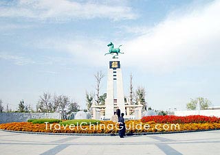
The Unearthed Place of Bronze Galloping Horse
Wuwei is the place where the emblem of China’s tourism, Bronze Galloping Horse Treading on a Flying Swallow, was unearthed. It is situated in the central area of Gansu Province and borders Lanzhou on the east, Xining on the south, Yinchuan and Inner Mongolia to the north and Xinjiang to the west. Wuwei, formerly known as Liangzhou, was historically the only route from central China to western regions and other Central Asian regions. And now it is also a vital city to the Eurasian Continental Bridge. As early as 2,000 years ago, people in Wuwei began to grow grapes and make wine, making Wuwei the hometown of Chinese wine. The snow mountains, oases, deserts and Godi in Wuwei paint a grand and breathtaking picture, along with the interest and historic sites adding more charm to this city.
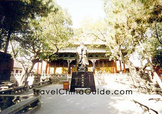
Located on the historical Silk Road, Wuwei is considered to be one of the most famous historical and cultural cities of China with plenty of historical recourses. There are numerous historical and cultural relics for sightseeing in the city. The most famous ones include the Confucian Temple, Leitai Tombs of Han Dynasty, Changcheng Town (Great Wall Town), Tianzhu Small Three Gorges, Shimengou Grassland Park and Tiantishan Grotto. When traveling in the city, you should not miss those worth seeing attractions.With an ancient architectural complex, the Confucian Temple is a place for worshiping Confucius. It was built in the Ming Dynasty and expanded many times, covering a total area of 1,500 square meters (16,145 square feet). There is a Wuwei Museum inside which collects more than 36,000 books, paintings, inscriptions and other cultural relics.
Leitai Han Tomb is a large-scale brick and stone tomb of the late Eastern Han Dynasty (25 - 220). Among the unearthed 99 exquisite bronze chariots and horses, the Bronze Galloping Horse, which is displayed in the Gansu Provincial Museum, is of the highest artistic value. Depicting a steed with three hooves soaring through the air and one poised atop a flying swallow, the sculpture captures the animal mid-gallop: its mouth agape, head thrown back, and muscles rippling with raw power. Deservedly dubbed the “ancient supercar”, it is celebrated worldwide for its innovative design and lifelike dynamism. Beyond its burial significance, Leitai was used to sacrifice the God of Thunder and has preserved 10 buildings of the Ming and Qing Dynasties (1368 - 1911).
|
|
How to get to/around Wuwei
2. It is easy to take train traveling from there to other cites in China. Wuwei Railway Station is located at Chengguan Town. It offers daily trains running to Lanzhou, Korla, Beijing, Jiayuguan, Urumqi, Dunhuang, Xian, Zhengzhou, Shanghai, Hangzhou, Chengdu, Chongqing, Shangqiu, Lianyungang, etc.
3. Wuwei Long-distance Bus Station is located at Nanguanxi Lu. It is the hinge of passenger bus transport in this city. There are buses daily traveling to Lanzhou, Zhangye, Tianshui, Jinchang, Jiuquan, Jiayuguan, Yumen, Dunhuang, Yinchuan, Xining, etc.
4. There are 15 public bus lines traveling around in downtown area now. Bus 1, 2, 12 and 102 can take you to City Railway Station. Bus 1, 2, 4, 5, 7, 8, 10 and 102 can take you to the long-distance bus station.
5. The taxi fare is different for different kind of Taxi. It is CNY3 (Alto)/CNY4 (Fukang)/CNY5 (Santana) for the first three kilometers and then CNY1/1.2/1.5 per additional kilometer.