Karamay Travel Guide
Karamay Facts
Chinese Name: 克拉玛依市 (kè lā mǎ yī shì)
Population: 460,000
Area: 7,733 square kilometers (2,986 square miles)
Location: in the northwest of Xinjiang, northwest China
Administrative Division: 4 districts (Karamay, Dushanzi, Baijiantan, Urho)
Area Code: 0990
Zip Code: 834000
GDP (2019): CNY 97.29 billion (USD 14.10 billion)
Nationalities: Han, Uygur, Kazak
A Modern Oil City with Unique Yardang Landform
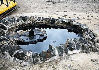
Karamay is situated in northwestern Xinjiang Uygur Autonomous Region at the edge of the Junggar Basin. The Tianshan Mountains zigzag south of the city, and the road mileage between Karamay and Urumqi is 313 kilometers (194 miles). Karamay means "black oil" in the Uyghur language. Once most areas of Karamay were desolate and backward, but now it is a livable modern city and an important oil and petrochemical base in China. While touring the fascinating cityscape, visitors can also enjoy the unique Yardang landform in the Ghost Town of World regarded as China’s 50 most worthy places for foreigners to go to, China's most beautiful highway - Dushanzi-Kuqa Highway and Poplar River Gorge with dense euphrates poplar forests.
Attractions:
![]() Ghost Town of World: Also called 'Urho Wind City', the Ghost Town is situated 110 kilometers (68 miles) northeast of the city, covering ten square kilometers of stunning Ya-dang landscape. When it is windy in spring and autumn, the rock formations blow like whistles, hence its name, the Ghost Town of World.
Ghost Town of World: Also called 'Urho Wind City', the Ghost Town is situated 110 kilometers (68 miles) northeast of the city, covering ten square kilometers of stunning Ya-dang landscape. When it is windy in spring and autumn, the rock formations blow like whistles, hence its name, the Ghost Town of World.
|
|
Tips:
1. Accommodation: There are hotels or hostels in Urho District or downtown area to stay. Besides, to camp around the gorge would be interesting.
2. As the gorge is at the desert area with strong sunshine, it is necessary to prepare sunglasses, sunscreen cream, and other wind-proof and sun-proof items.
| Admission Fee | CNY20 |
| Opening Hours | 08:00 - 18:00 |
| Best Season/Time to Travel | 1. Summer and Autumn 2. During the Eid-ul-Fitr, Corban Festival and Water-Sprinkling Festival |
| Transportation | 1. There are tourism buses between these two places in operation. 2. It is recommended to rent a car or take a taxi to get there. |
|
|
How to Get to Karamay
Karamay Airport is 17 kilometers (11 miles) from the city's downtown area. At present, only one daily flight leaves for Urumqi in the morning for an hour's journey. If going to Urumqi from the bus station of Karamay, a ten hours' drive may be needed.
Weather
The region has a typical continental climate characterized by a lack of rain and quite windy spring and autumn. Winter is extremely cold and summer is roasting, generating a large temperature difference between these two seasons. Comparatively, its spring and autumn are short during a year.