10 Key Yangtze River Facts
Basic Facts of Yangtze River:
Chinese name: 长江 (Cháng Jiāng)
Other names: Yangtse/ Yangzi River
Length: over 6,300 kilometers (3,915 miles)
Source: Glacier of Jianggendiru, southwest to Geladandong Peak, the main peak of Tanggula Mountain
Source elevation: 5,820 m (19,095 ft)
Location: 24°30′-35°45′N, 90°33′-112°25′E
Influx into: East China Sea
Average runoff in estuary: 33,980 cubic meters per second (1,200,000 cubic feet per second)
Annual average runoff: 960 billion cubic meters
River basin: 1,800,000 square km (694,983 square miles)
History: 3 million years
Yangtze River Maps
1. Yangtze River is the longest river in Asia and the third longest in the world.
Yangtze River is as long as 6,397 km (3,975 miles). It is the longest river in Asia and the third longest river in the world, just after the Nile in Africa and the Amazon in South America. It runs across central China from Qinghai-Tibet Plateau in the west to East China Sea in the east. This fact of Yangtze River makes it great among famous rivers.
2. The source of Yangtze River is at Qinghai-Tibet Plateau.
Yangtze River starts from Jianggendiru Glacier, the southwest side of Geladandong Peak, the main peak of Tanggula Mountains, where is next to Kunlun Mountains, in the back-land of Qinghai-Tibet Plateau in western China. After this, it flows eastwards and pours itself into the East China Sea.
3. It is a natural dividing line of North and South China.
Strictly, the geographical dividing line of North-South China is the Qinling Mountains-Huai River. However, the Yangtze is also regarded as the natural boundary of South and North China. To the north of Yangtze River, the climate is dry with lower temperature and less rain; while to its south it is warm and humid with adequate rainfall. The main grain is wheat in the north and rice in the south, thus northern people usually eat various wheat-based food as their staple, and southern people prefer rice. Northerners are more forthright, while the southerners are moderate and gentle on the whole.
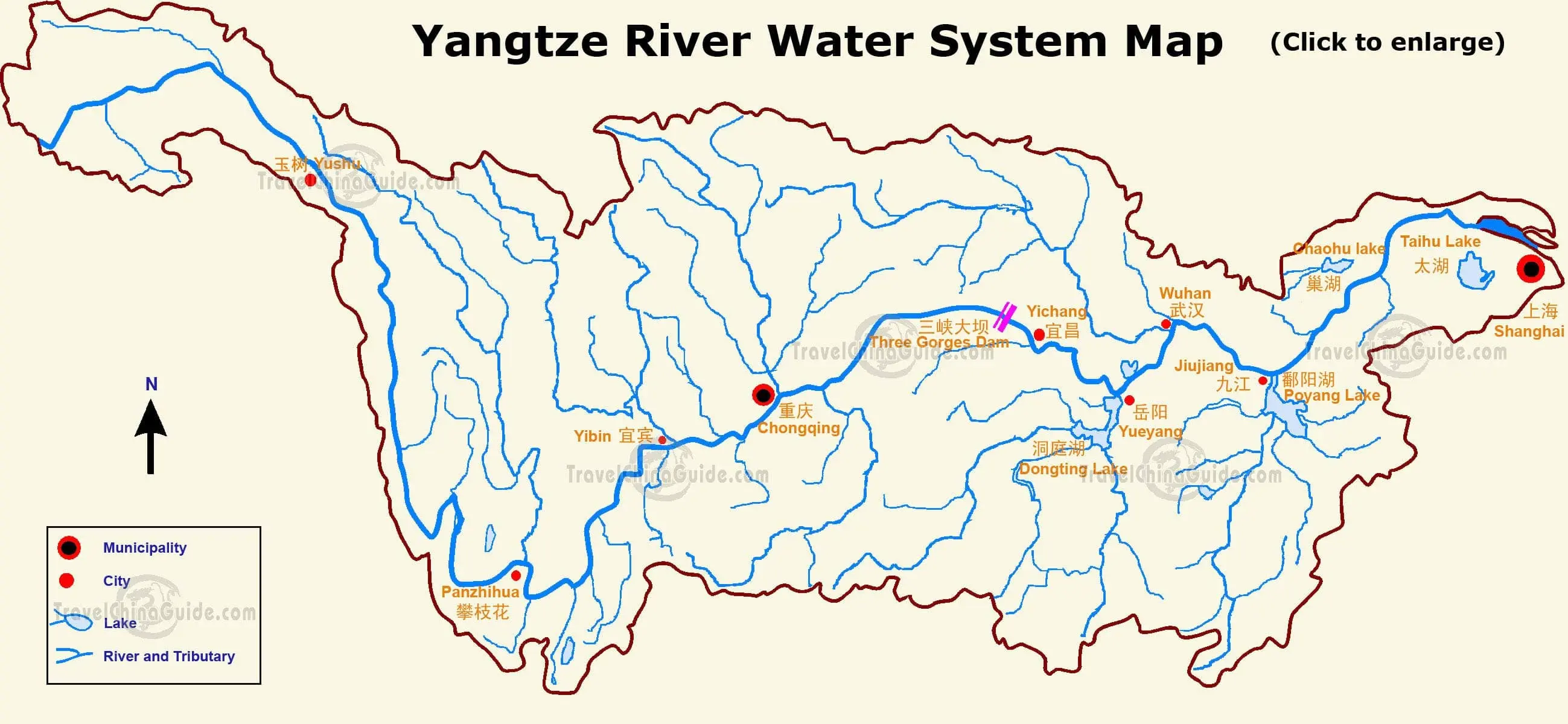 |
| Water System Map (Click the map to enlarge it) |
4. The drainage basin of Yangtze River takes 1/5 of China’s land area.
The drainage area of Yangtze River is quite large, which is 1.8 million square kilometers. The basin accounts for one fifth of total land area in China. The Yangtze River flows through 11 provincial-level administrative regions, including Qinghai, Tibet, Sichuan, Yunnan, Chongqing, Hubei, Hunan, Jiangxi, Anhui, Jiangsu and Shanghai.
5. Major Cities along Yangtze River
The major cities along Yangtze River are Chongqing, Yichang, Wuhan, Nanjing and Shanghai. All of their agriculture, tourism, transportation and industry benefit a lot from the Yangtze. Other cities along the Yangtze include Panzhihua, Yibin, Luzhou, Jingzhou, Shashi, Shishou, Ezhou, Xianning, Huangshi, Huanggang, Yueyang, Hefei, Chaohu, Chizhou, Anqing, Tongling, Wuhu, Chuzhou, Maanshan, Jiujiang, Suzhou, Yangzhou, Zhenjiang, Jiangyin, Nantong and Taizhou.
6. Yangtze River Delta is the most prosperous and populous area in China.
The Yangtze River Delta accounts for 10% of population and 20% of GDP in China. The GDP of Shanghai reached CNY 3,268 billion in 2018. The cities with a population of over one million include Shanghai, Nanjing, Hangzhou and Suzhou. Besides, it is a big granary of the country. The grain it produces covers a half of the whole nation, of which the rice accounts for 70% in the total.
7. The most popular Yangtze River cruise tour is between Chongqing and Yichang.
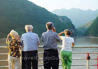 |
| Yangtze Cruise |
This Yangtze River fact should be remembered by those who are planning a trip. A cruise is the most popular way to tour Yangtze River. The route between Chongqing and Yichang is the most popular one. The ships are built as four-star standard or above. It takes 4 days and 3 nights from Chongqing to Yichang downstream, and 5 days and 4 nights from Yichang to Chongqing upstream. The cruise ship will pass through the Three Gorges, the gathering of Qutang Gorge, Wu Gorge and Xiling Gorge, which are lined with fantastic rocks and peaks on both banks. The ship will also stop over at Three Gorges Dam, the largest dam and hydropower station in China, which benefits a lot of people. Visitors can also go for excursions to Fengdu Ghost City, Shibaozhai and Shennong Stream on the route.![]() See more Yangtze Cruise Tours
See more Yangtze Cruise Tours
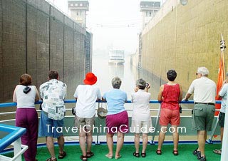 |
| Gezhouba Dam, Yichang |
8. There is the world’s largest hydropower station, Three Gorges Dam, on the Yangtze.
Three Gorges Dam play a momentous role in flood control, electricity generation, shipping, aquaculture, tourism, irrigation, and so on. It is the world’s largest hydropower station. 100 billion kWh electricity is generated in a year, which meets the daily needs of about 200 million people in a dozen of provinces. This is a fact of Yangtze River that many Chinese are proud of.![]() See more about Yangtze River Dam – 5 Secrets You don’t Know
See more about Yangtze River Dam – 5 Secrets You don’t Know
9. Yangtze River has more than 700 tributaries.
It’s an amazing Yangtze River fact that it has over 700 tributaries. Among these tributaries, 8 have the basin area of over 50,000 square kilometers (19,305 sq mi), and 5 have a length of more than 1,000 kilometers (621 miles). The tributary with the largest runoff is the Minjiang River. The tributary with the largest basin is the Jialing River. The tributaries with the longest length are Hanjiang River and Ya-lung River. Other large tributaries of Yangtze River include Wujiang River, Ruanjiang River, Xiang River and Ganjiang River.
10. Yangtze River has great influence on Chinese culture since ancient times.
The same as the Yellow River, Yangtze River is also the cradle of Chinese civilization and reputed “Mother River” of China. Yangtze River gestated Hemudu Culture in its lower reaches about 7,000 years ago. Later, it gave birth to southern Chinese cultures, like Chu Culture, Wu and Yue Culture, etc. It has provided water for the lives of people and for irrigating crops. It has been a natural route of transportation. It still breeds one third of Chinese population nowadays.
![]() Further Reading
Further Reading
How serious is the Yangtze River pollution?
Yangtze River History: Past and Present