Nagqu (Naqu) Travel Guide
Nagqu (Nachu)Facts
Chinese Name: 那曲 (nà qǔ)
Population: 503,700
Area: 430,000 square kilometers (166,024 square miles)
Location: in the north of Tibet, southwest China
Administrative Division: 10 counties (Nagqu, Lhari, Driru, Nyainrong, Amdo, Xainza, Sog, Palgon, Drachen, Nyima); 1 special district (Shuanghu Special District)
Area Code: 0896
Zip Code: 852000
GDP (2018): CNY 13.65 billion (USD 2.06 billion)
Nationalities: Tibetan, Han
North Gate of Tibet Famous for Sacred Namtso Lake
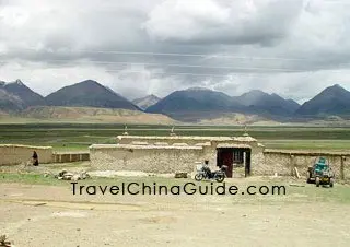
Nachu Prefecture stands in the vast land of northern Tibet Autonomous Region, neighboring Xinjiang and Qinghai to the north. Within Tibet, it is bordered by Chamdo to the east, Lhasa to the south and Ngari to the west. The city's average altitude is more than 4,500 meters (14,764 feet) and it is hypoxic and dry. Despite the harsh climate, many visitors are still attracted by the clear sky, sparkling lakes, lofty mountains and vast grasslands.
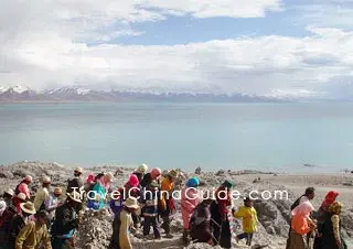
The central attraction here is Namtso Lake, one of the three sacred lakes in Tibet. In the south of Namtso Lake is Mt. Nyainqentanglha, which is covered with snow all year round. In the folk songs and legends of local shepherds and hunters, Nianqing Tanggula Mountain and Namtso are incarnations of a couple.![]() Pictures
Pictures
![]() Mt. Nyainqentanglha: Driving 100 kilometers (62 miles) northward after leaving Lhasa and traversing the Yangpachen, visitors can see the mountain right in front of you. The snow-capped mountain with clouds wafting around the lofty peak is spoken of as a famous religious patron saint in Tibet, which is considered to be the chief sacred mountain in northern Tibet. Both Bonist and Buddhist disciples venerate it as the ashram of divinities. Namtso Lake and Changtang (Qiangtang) Pasture are all famous spots of this area.
Mt. Nyainqentanglha: Driving 100 kilometers (62 miles) northward after leaving Lhasa and traversing the Yangpachen, visitors can see the mountain right in front of you. The snow-capped mountain with clouds wafting around the lofty peak is spoken of as a famous religious patron saint in Tibet, which is considered to be the chief sacred mountain in northern Tibet. Both Bonist and Buddhist disciples venerate it as the ashram of divinities. Namtso Lake and Changtang (Qiangtang) Pasture are all famous spots of this area.
|
|
How to Get to Nagqu
Nagqu Railway Station is seated in Emadige Village of Mendi Township, which is about two kilometers (1.2 miles) from the county. Trains from Lhasa to Lanzhou, Xining, Chongqing, Chengdu and Beijing all make short stops at the station.
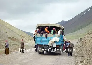
Nagqu is a main stop on the Qinghai-Tibet Highway. There are many regular buses to Lhasa and Qinghai Province. Visitors can find the bus station at 25, Zhejiang Dong Lu, Nagqu Town. For individual tourists arriving from Qinghai, the regular or state-owned bus fleet is quite dependable.
Recommended Tour Itineraries:
Qinghai-Tibet Overland Journey: 12 Days of Xining - Qinghai Lake - Golmud - Tuotuo River - Nagqu - Lhasa - Gyangtse - Shigatse – Lhasa
Nagqu Tour: 3-day hiking route
Weather
Belonging to the second frigid climatic zone, the region is characterized by high altitude, coldness, lack of oxygen, dry and windy weather. Its annual average temperature falls around -3.3℃to -0.9 (26.1-30.4℉). November to March is the dry season. The weather is warm during the period from May to September, and this is the golden season for the grassland there.
The best time to visit Nachu is from May to September when the weather is relatively warm. Especially in August, the grand Nachu Horse Racing Festival is particularly lively. The herdsmen dress in gorgeous traditional costumes and bring their own tents. During the festival, there will be performances, various folk sports such as tug of war, long jump and other religious activities.
Nagqu Travel Tips
![]() History: Nagqu area was known as 'Zhuodai' in the historical records and means pasturing tribe, Nomads living there were called 'Zhuoba' of 'Qiangba'. Before the 7th Century, the Supi tribe governed this area. As the Tubo tribe became stronger and established its own regime in the 7th century, the area was brought into the sphere of the new dynasty. After the Song Dynasty (960-1279), it was one of the four major tribes in northern Tibet.
History: Nagqu area was known as 'Zhuodai' in the historical records and means pasturing tribe, Nomads living there were called 'Zhuoba' of 'Qiangba'. Before the 7th Century, the Supi tribe governed this area. As the Tubo tribe became stronger and established its own regime in the 7th century, the area was brought into the sphere of the new dynasty. After the Song Dynasty (960-1279), it was one of the four major tribes in northern Tibet.
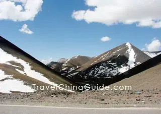
![]() Physical Features: The region is embraced by the mountains of Tanggula, Kangdese and Nyainqentanglha, guarded by snow capped Dargo Mountain in the west and Burgyi Mountain in the east. Its terrain slopes downward from the west to the east. The average altitude of the region is over 4,500 meters (14,764 feet). Its eastern part holds a river valley which is the only agricultural belt in northern Tibet.
Physical Features: The region is embraced by the mountains of Tanggula, Kangdese and Nyainqentanglha, guarded by snow capped Dargo Mountain in the west and Burgyi Mountain in the east. Its terrain slopes downward from the west to the east. The average altitude of the region is over 4,500 meters (14,764 feet). Its eastern part holds a river valley which is the only agricultural belt in northern Tibet.
![]() Local Highlights: The Horse Racing Festival, held every August, is quite an occasion to admire the natural landscape and folkcustoms of the grassland of northern Tibet. The unpopulated area in northern Tibet is mysterious for tourists. Wild yaks and antelopes inhabit this land. Rock paintings discovered in the undeveloped virgin ground add more mystery and charms to the deserted landscape.
Local Highlights: The Horse Racing Festival, held every August, is quite an occasion to admire the natural landscape and folkcustoms of the grassland of northern Tibet. The unpopulated area in northern Tibet is mysterious for tourists. Wild yaks and antelopes inhabit this land. Rock paintings discovered in the undeveloped virgin ground add more mystery and charms to the deserted landscape.
![]() Special Local Products: dried meat of yak and sheep, ghee, cashmere, decorations
Special Local Products: dried meat of yak and sheep, ghee, cashmere, decorations
|
|