Harbin Subway
Harbin Metro now runs three lines. Line 1 runs from Harbin East Railway Station to Xinjiang Street, passing Harbin South Railway Station and the Museum of Heilongjiang Province. Line 2 crosses the Songhua River from Jiangbei University Town to Meteorological Observatory, serving Ice and Snow World, Sun Island, Central Street, and Harbin Railway Station. Line 3 is a 36-station loop through the old urban core, linking Harbin West Railway Station, the Chinese Baroque Historic Block, Harbin Mosque, the Convention and Exhibition Center, Sports Park, and Qunli Wetland Park. Harbin Metro is China's first rail transit system built for high-altitude and severe cold regions.
 Line 1 — Harbin East Railway Station – Xinjiang Street
Full length: 27.3 kilometers (about 17.0 miles), 23 stations.
It's China's first metro line built for severe cold regions, running via Harbin South Railway Station, Museum (transfer with Line 2), The Second Affiliated Hospital of Harbin Medical University (transfer with Line 3), and Taipingqiao (transfer with Line 3).
Line 2 — Jiangbei University Town – Meteorological Observatory
Full length: 28.7 kilometers (about 17.8 miles), 19 stations.
The first metro line to cross the Songhua River underground.
Key stops for travelers: Harbin North Railway Station, Ice and Snow World, Sun Island, People's Square (transfer with Line 3), Central Street, Shangzhi Street (5-min walk to St. Sophia Church), Harbin Railway Station, Museum (transfer with Line 1), Provincial Government, Zhujiang Road (transfer with Line 3), Northeast Agricultural University.
Line 3 — Circular loop
Full length: about 32.2 kilometers (about 20.0 miles), 36 stations.
Major interchanges: The Second Affiliated Hospital of Harbin Medical University and Taipingqiao (with Line 1); People's Square and Zhujiang Road (with Line 2). Key traveler stops: Harbin West Railway Station, Kaishengyuan Plaza, Haxi Street, Sports Park, Convention and Exhibition Center, Jingyu Park, Harbin Mosque, Chinese Baroque Historic Block, Zhaolin Park, Friendship Palace (for Songhua River bank and north end of Central Street).
Harbin Metro uses a distance-based fare starting at CNY 2 and capping at CNY 7 for the longest possible ride. Most of the rides a visitor actually takes usually costs CNY 2-3.
How to pay: Tickets can be purchased at self-service machines or manual counters inside the stations with cash or bank card like Visa or Mastercard. Passengers can also show the QR transport codes on Alipay or WeChat Pay directly for entrance.
Discounts for tourists: Children under 1.2 m (3.9 ft) ride free.
Lines 4 and 5 are included in the approved 2021–2035 Harbin Metro Network Plan and are awaiting final approval for construction. Lines 6 through 10, still in the early planning stage, have not yet been formally approved or funded for construction.
Line 4
Main line: Daxin Street – Wanggang
Length: 19.15 kilometers (about 11.90 miles)
Stations: Daxin Street, Chengde Square, Anji Street, Tobacco Factory, Kuancheng Street (transfer with Line 5), Xuanqing Street, Provincial Government (transfer with Line 2 and Line 4 branch), Flax Factory, Dongli Square, Botanical Garden, Xuefu Middle School, The Second Affiliated Hospital of City Medical University, Youjia Street, Yangmajiazi, Fushantun, Heilongjiang Province Agricultural Mechanization College, Wanggang
Branch: Provincial Government – Huagong Road
Length: 6 kilometers (about 4 miles)
Stations: Provincial Government, Hengshan Road, Convention and Exhibition Center, Xinchunxiang, Huagong Road
Line 5
Main line: Longfeng Road – New Technology Development Zone
Length: 19.15 kilometers (about 11.90 miles)
Stations: Longfeng Road, General Chemical Factory, Paint Factory, Heping Residence Community, Hongqi Street, Huashan Road, Kuancheng Street, Longjiang Street, Railway Station, Anfaqiao, Central Hospital, Kang'an Road, Xinting Street, Construction Machinery Factory, Gear Factory, Youyi Village, Water Supply Equipment Factory, Tianping Road, New Technology Development Zone
Branch: Xinting Street – Dongfeng Town
Length: 8.7 kilometers (about 5.4 miles)
Stations: Xinting Street, Chaoxiantun, Shuiyuan Road, 3rd Ring Road, Sifangtai, Qunli New Zone
Line 6
Planned to start at Hongqi Street and pass about 24 stations including Convention and Exhibition Center, Minjiang Residence Community, Dianli Hospital, Weisheng Street, Qingbin Road, Guxiang, etc.
Line 7
Planned to start at Sun Island and pass about 25 stations including Central Street, Binjiang, East Dazhi Street, Guogeli Street, etc.
Line 8
Hulan – Songpu
Full length: 27 kilometers (about 17 miles)
Number of stations: 11
Line 9 (airport line)
Taiping International Airport – Harbin West Railway Station
Full length: 28 kilometers (about 17 miles)
Number of stations: 12
Line 10
Jinxiang Street – Acheng District
Full length: 22 kilometers (about 14 miles)
Number of stations: 7
Operating Subway Lines
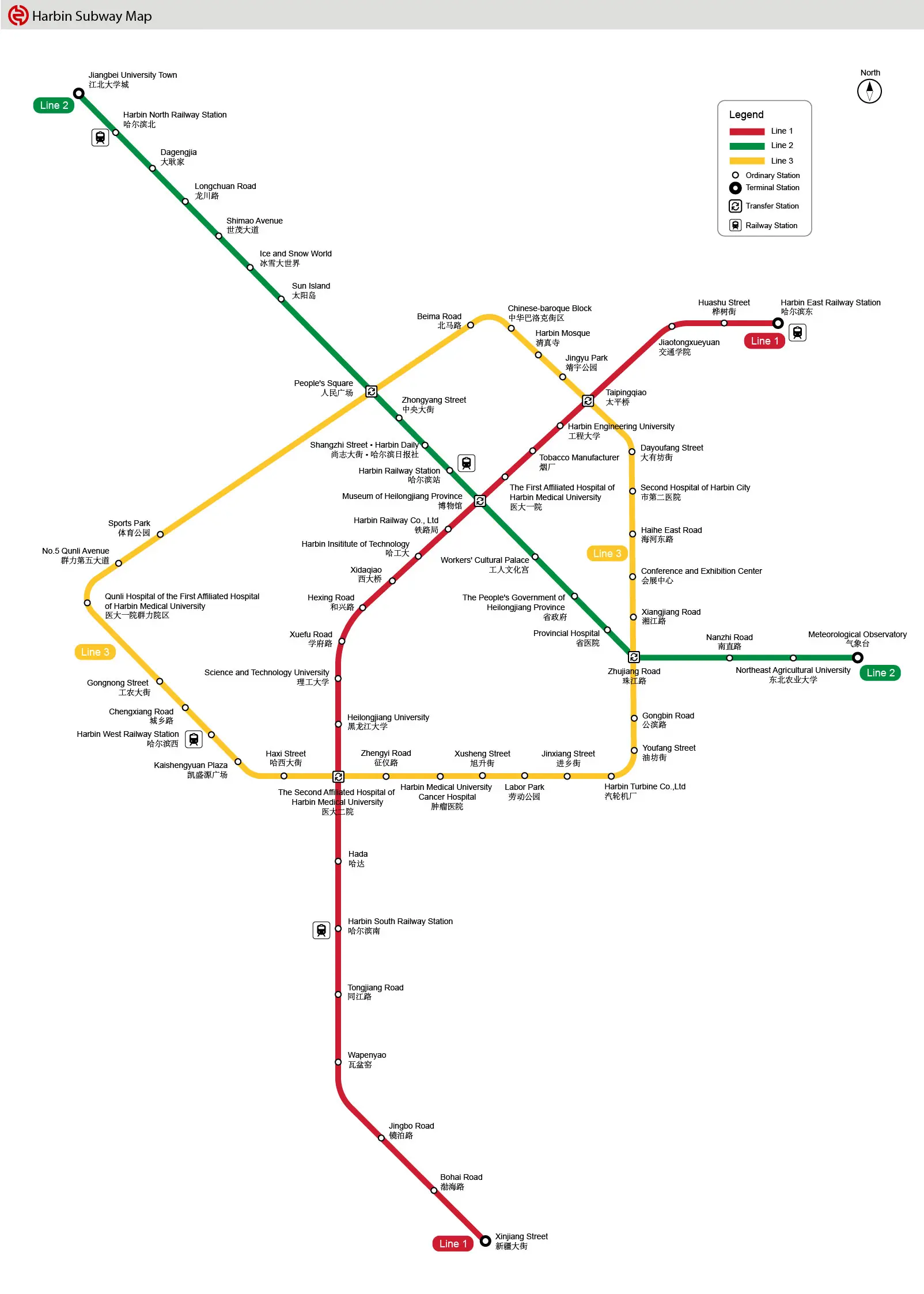 |
| Click the map to enlarge it, or go for more Harbin Subway Maps |
Line 1 — Harbin East Railway Station – Xinjiang StreetFull length: 27.3 kilometers (about 17.0 miles), 23 stations.
It's China's first metro line built for severe cold regions, running via Harbin South Railway Station, Museum (transfer with Line 2), The Second Affiliated Hospital of Harbin Medical University (transfer with Line 3), and Taipingqiao (transfer with Line 3).
Line 2 — Jiangbei University Town – Meteorological ObservatoryFull length: 28.7 kilometers (about 17.8 miles), 19 stations.
The first metro line to cross the Songhua River underground.
Key stops for travelers: Harbin North Railway Station, Ice and Snow World, Sun Island, People's Square (transfer with Line 3), Central Street, Shangzhi Street (5-min walk to St. Sophia Church), Harbin Railway Station, Museum (transfer with Line 1), Provincial Government, Zhujiang Road (transfer with Line 3), Northeast Agricultural University.
Line 3 — Circular loopFull length: about 32.2 kilometers (about 20.0 miles), 36 stations.
Major interchanges: The Second Affiliated Hospital of Harbin Medical University and Taipingqiao (with Line 1); People's Square and Zhujiang Road (with Line 2). Key traveler stops: Harbin West Railway Station, Kaishengyuan Plaza, Haxi Street, Sports Park, Convention and Exhibition Center, Jingyu Park, Harbin Mosque, Chinese Baroque Historic Block, Zhaolin Park, Friendship Palace (for Songhua River bank and north end of Central Street).
Harbin Metro Ticket Fare
| Route | Fare |
|---|---|
| Harbin Railway Station → Central Street | CNY 2 |
| Harbin Railway Station → St. Sophia Church (alight at Shangzhi Street) | CNY 3 |
| Central Street → Ice and Snow World | CNY 3 |
| Central Street → Sun Island | CNY 3 |
| Harbin West Railway Station → Chinese-baroque Block | CNY 3-4 |
| Harbin North Railway Station → Central Street | CNY 4 |
How to pay: Tickets can be purchased at self-service machines or manual counters inside the stations with cash or bank card like Visa or Mastercard. Passengers can also show the QR transport codes on Alipay or WeChat Pay directly for entrance. Discounts for tourists: Children under 1.2 m (3.9 ft) ride free. Harbin Metro Future Lines: Approved Plans & Long-Term Vision
Line 4Main line: Daxin Street – Wanggang
Length: 19.15 kilometers (about 11.90 miles)
Stations: Daxin Street, Chengde Square, Anji Street, Tobacco Factory, Kuancheng Street (transfer with Line 5), Xuanqing Street, Provincial Government (transfer with Line 2 and Line 4 branch), Flax Factory, Dongli Square, Botanical Garden, Xuefu Middle School, The Second Affiliated Hospital of City Medical University, Youjia Street, Yangmajiazi, Fushantun, Heilongjiang Province Agricultural Mechanization College, Wanggang
Branch: Provincial Government – Huagong Road
Length: 6 kilometers (about 4 miles)
Stations: Provincial Government, Hengshan Road, Convention and Exhibition Center, Xinchunxiang, Huagong Road
Line 5Main line: Longfeng Road – New Technology Development Zone
Length: 19.15 kilometers (about 11.90 miles)
Stations: Longfeng Road, General Chemical Factory, Paint Factory, Heping Residence Community, Hongqi Street, Huashan Road, Kuancheng Street, Longjiang Street, Railway Station, Anfaqiao, Central Hospital, Kang'an Road, Xinting Street, Construction Machinery Factory, Gear Factory, Youyi Village, Water Supply Equipment Factory, Tianping Road, New Technology Development Zone
Branch: Xinting Street – Dongfeng Town
Length: 8.7 kilometers (about 5.4 miles)
Stations: Xinting Street, Chaoxiantun, Shuiyuan Road, 3rd Ring Road, Sifangtai, Qunli New Zone
Line 6Planned to start at Hongqi Street and pass about 24 stations including Convention and Exhibition Center, Minjiang Residence Community, Dianli Hospital, Weisheng Street, Qingbin Road, Guxiang, etc.
Line 7Planned to start at Sun Island and pass about 25 stations including Central Street, Binjiang, East Dazhi Street, Guogeli Street, etc.
Line 8Hulan – Songpu
Full length: 27 kilometers (about 17 miles)
Number of stations: 11
Line 9 (airport line)Taiping International Airport – Harbin West Railway Station
Full length: 28 kilometers (about 17 miles)
Number of stations: 12
Line 10Jinxiang Street – Acheng District
Full length: 22 kilometers (about 14 miles)
Number of stations: 7
- Last updated on Aug. 19, 2026 by Jally Zhang -