Shanghai Metro
Shanghai Metro Sign 
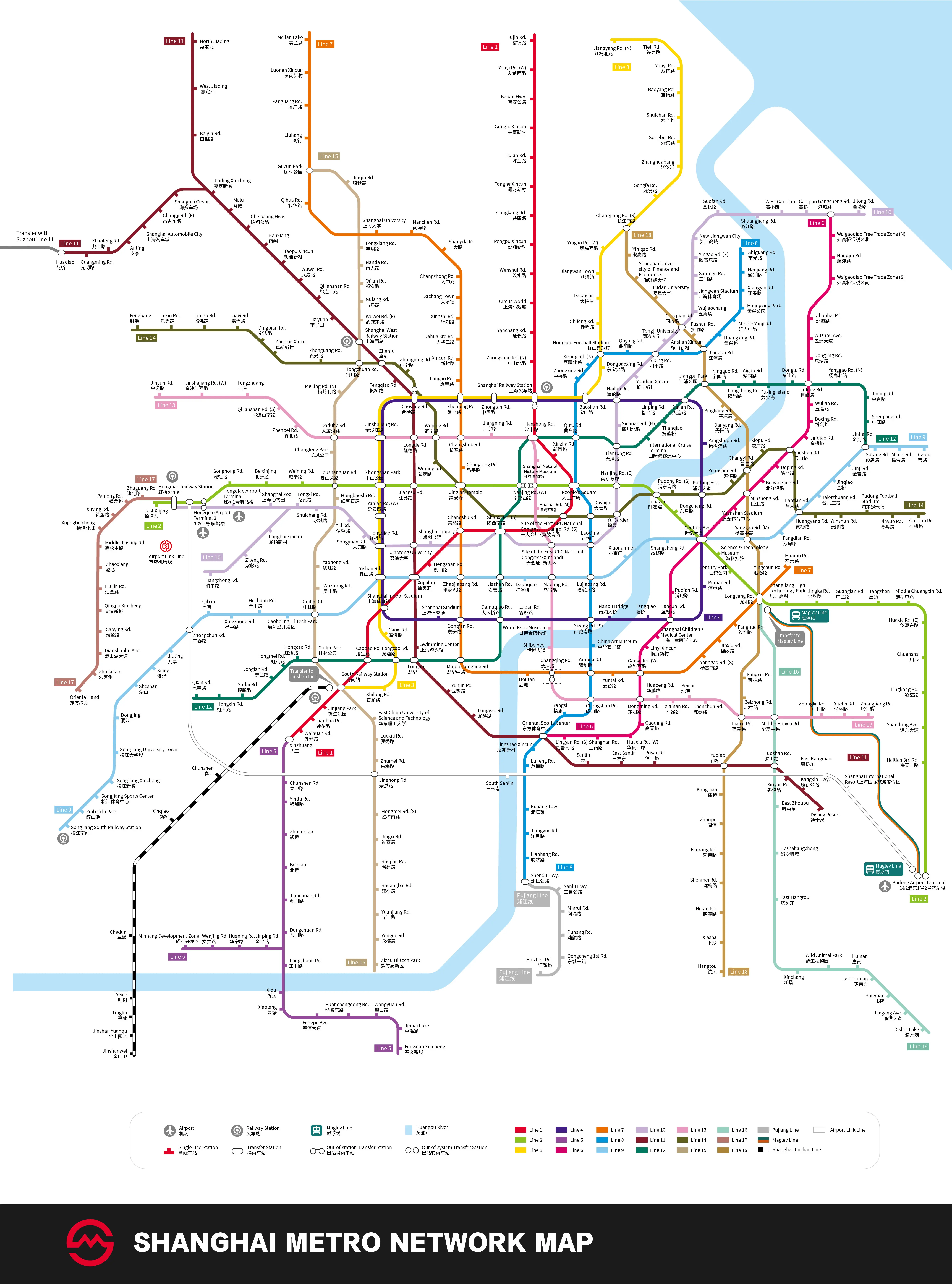 |
| Metro Map |
Shanghai Metro is a speedy, safe, comfortable and convenient means of transportation for traveling around the city. The main attractions, transportation hubs and commercial areas such as the Bund, Nanjing Road, Huaihai Road, People's Square, Shanghai Railway Station and Xujiahui can be reached by several metro lines.
At present, there are 20 Shanghai subway lines in operation (including Shanghai Maglev Train), totaling 831 kilometers (516.4 miles). The right is a metro map (English-Chinese version) for your reference, including the present 20 lines and several sections under construction or still being programmed. Please click the map to enlarge it. Also you can see the English Version and the Chinese Version, or go for more Metro Maps.
 |
Lines in Operation
 |
Identification Color: red
Total Length: 37 kilometers (23 miles)
Stations: Xinzhuang ↔ Waihuan Rd. ↔ Lianhua Rd. ↔ Jinjiang Park ↔ South Railway Station ↔ Caobao Rd. ↔ Indoor Stadium ↔ Xujiahui ↔ Hengshan Rd. ↔ Changshu Rd. ↔ South Shanxi Rd. ↔ South Huangpi Rd. ↔ People's Square ↔ Xinzha Rd. ↔ Hanzhong Rd. ↔ Shanghai Railway Station (South Square) ↔ North Zhongshan Rd. ↔ Yanchang Rd. ↔ Circus World ↔ Wenshui Rd. ↔ Pengpu Xincun ↔ Gongkang Rd. ↔ Tonghe Xincun ↔ Hulan Rd. ↔ Gongfu Xincun ↔ Baoan Highway ↔ West Youyi Rd. ↔ Fujin Rd.
![]() Line 2: Panxiang Road · Shanghai National Accounting Institute ↔ Guanglan Rd. ↔ Pudong Airport
Line 2: Panxiang Road · Shanghai National Accounting Institute ↔ Guanglan Rd. ↔ Pudong Airport
Identification Color: light green
Total Length: about 66 kilometers (40 miles)
Stations: Panxiang Road · Shanghai National Accounting Institute ↔ Hongqiao Railway Station ↔ Hongqiao Airport T2 ↔ Songhong Rd. ↔ Beixinjing ↔ Weining Rd. ↔ Loushanguan Rd. ↔ Zhongshan Park ↔ Jiangsu Rd. ↔ Jing'an Temple ↔ West Nanjing Rd. ↔ People's Square ↔ East Nanjing Rd. ↔ Lujiazui ↔ Pudong South Rd. ↔ Century Avenue ↔ Science & Technology Museum ↔ Century Park ↔ Longyang Rd. ↔ Zhangjiang High Technology Park ↔ Jinke Rd. ↔ Guanglan Rd.
* At Longyang Rd. Station near the east end of Subway Line 2, the fast Maglev Train (SMT) can take you to Pudong International Airport within eight minutes. The train operates every day from 6:45 to 21:32 at an interval of 15 to 30 minutes. It costs CNY 50 one-way (economic) and CNY 100 for VIP, CNY 80 round-trip (economic) and CNY 160 for VIP.
![]() Line 3: South Railway Station ↔ North Jiangyang Rd.
Line 3: South Railway Station ↔ North Jiangyang Rd.
Identification Color: yellow
Total Length: 40 kilometers (25 miles)
Stations: South Railway Station ↔ Shilong Rd. ↔ Longcao Rd. ↔ Caoxi Rd. ↔ Yishan Rd. ↔ Hongqiao Rd. ↔ West Yan'an Rd. ↔ Zhongshan Park ↔ Jinshajiang Rd. ↔ Caoyang Rd. ↔ Zhenping Rd. ↔ Zhongtan Rd. ↔ Shanghai Railway Station (North Square) ↔ Baoshan Rd. ↔ Dongbaoxing Rd. ↔ Hongkou Football Stadium ↔ Chifeng Rd. ↔ Dabaishu ↔ Jiangwan Town ↔ West Yingao Rd. ↔ South Changjiang Rd. ↔ Songfa Rd. ↔ Zhanghuabang ↔ Songbin Rd. ↔ Shuichan Rd. ↔ Baoyang Rd. ↔ Youyi Rd. ↔ Tieli Rd. ↔ North Jiangyang Rd.
![]() Line 4 (Circle Line): Yishan Rd. ↔ Century Avenue ↔ Shanghai Railway Station ↔ Zhongshan Park (↔ Yishan Rd.)
Line 4 (Circle Line): Yishan Rd. ↔ Century Avenue ↔ Shanghai Railway Station ↔ Zhongshan Park (↔ Yishan Rd.)
 |
| Ticket Machine |
Total Length: 34 kilometers (21 miles)
Shanghai Indoor Stadium ↔ Yishan Road ↔ Hongqiao Road ↔ West Yan'an Road ↔ Zhongshan Park ↔ Jinshajiang Road ↔ Caoyang Road ↔ Zhenping Road ↔ Zhongtan Road ↔ Shanghai Railway Station ↔ Baoshan Road ↔ Hailun Road ↔ Linping Road ↔ Dalian Road ↔ Yangshupu Road ↔ Pudong Avenue ↔ Century Avenue ↔ Xiangcheng Road ↔ Lancun Road ↔ Tangqiao ↔ Nanpu Bridge ↔ South Xizang Road ↔ Luban Road ↔ Damuqiao Road ↔ Dong'an Road ↔ Shanghai Stadium ↔ Inner Circle ↔ Outer Circle ↔ Inner Circle (Yishan Road) ↔ Outer Circle (Yishan Road)
![]() Line 5: Main Line: Xinzhuang – Fengxian Xincheng; Branch Line: Dongchuan Rd. - Minhang Development Zone
Line 5: Main Line: Xinzhuang – Fengxian Xincheng; Branch Line: Dongchuan Rd. - Minhang Development Zone
Identification Color: purple
Total Length: 33 kilometers (21 miles)
Stations: Main Line: Xinzhuang ↔ Chunshen Rd. ↔ Yindu Rd. ↔ Zhuanqiao ↔ Beiqiao ↔ Jianchuan Rd. ↔ Dongchuan Rd. ↔ Jiangchuan Road ↔ Xidu ↔ Xiaotang ↔ Fengpu Avenue ↔ Huanchengdong Road ↔ Wangyuan Road ↔ Jinhai Lake ↔ Fengxian Xincheng
Branch Line: Dongchuan Rd. ↔ Jinping Rd. ↔ Huaning Rd. ↔ Wenjing Rd. ↔ Minhang Development Zone
![]() Line 6: Gangcheng Rd. ↔ Oriental Sports Center
Line 6: Gangcheng Rd. ↔ Oriental Sports Center
Identification Color: pinkish red
Total Length: 33.5 kilometers (21 miles)
Stations: Gangcheng Rd. ↔ Waigaoqiao Free Trade Zone (N) ↔ Hangjin Rd. ↔ Waigaoqiao Free Trade Zone (S) ↔ Zhouhai Rd. ↔ Wuzhou Avenue ↔ Dongjing Rd. ↔ Jufeng Rd. ↔ Wulian Rd. ↔ Boxing Rd. ↔ Jinqiao Rd. ↔ Yunshan Rd. ↔ Deping Rd. ↔ Beiyangjing Rd. ↔ Minsheng Rd. ↔ Yuanshen Sports Center ↔ Century Avenue ↔ Pudian Rd. ↔ Lancun Rd. ↔ Children's Medical Center ↔ Linyi Xincun ↔ West Gaoke Rd. ↔ Dongming Rd. ↔ Gaoqing Rd. ↔ West Huaxia Rd. ↔ Shangnan Rd. ↔ South Lingyan Rd.↔ Oriental Sports Center
![]() Line 7: Huamu Rd. ↔ Meilan Lake
Line 7: Huamu Rd. ↔ Meilan Lake
Identification Color: orange
Total Length: 44 kilometers (27 miles)
Stations: Huamu Rd. ↔ Longyang Rd. ↔ Fanghua Rd. ↔ Jinxiu Rd. ↔ South Yanggao Rd. ↔ West Gaoke Rd. ↔ Yuntai Rd. ↔ Yaohua Rd. ↔ Changqing Rd. ↔ Houtan ↔ Middle Longhua Rd. ↔ Dong'an Rd. ↔ Zhaojiabang Rd. ↔ Changshu Rd. ↔ Jing'an Temple ↔ Changping Rd. ↔ Changshou Rd. ↔ Zhenping Rd. ↔ Langao Rd. ↔ Xincun Rd. ↔ Dahua 3rd Rd. ↔ Xingzhi Rd. ↔ Dachang Town ↔ Changzhong Rd. ↔ Shangda Rd. ↔ Nanchen Rd. ↔ Shanghai University ↔ Qihua Rd. ↔ Gucun Park ↔ Liuhang ↔ Panguang Rd. ↔ Luonan Xincun ↔ Meilan Lake
![]() Line 8: Shiguang Rd. ↔ Shendu Highway
Line 8: Shiguang Rd. ↔ Shendu Highway
Total Length: 37 kilometers (23 miles )
Stations: Shiguang Rd. ↔ Nenjiang Rd. ↔ Xiangyin Rd. ↔ Huangxing Park ↔ Middle Yanji Rd. ↔ Huangxing Rd. ↔ Jiangpu Rd. ↔ Anshan Xincun ↔ Siping Rd. ↔ Quyang Rd. ↔ Hongkou Football Stadium ↔ North Xizang Rd. ↔ Zhongxing Rd. ↔ Qufu Rd. ↔ People's Square ↔ Dashijie ↔ Laoximen ↔ Lujiabang Rd. ↔ South Xizang Rd. ↔ China Art Museum ↔ Yaohua Rd. ↔ Chengshan Rd. ↔ Yangsi ↔ Oriental Sports Center ↔ Lingzhao Xincun ↔ Luheng Rd. ↔ Pujiang Town ↔ Jiangyue Rd. ↔ Lianhang Rd. ↔ Shendu Highway
![]() Line 9: Caolu ↔ Songjiang South Railway Station
Line 9: Caolu ↔ Songjiang South Railway Station
Identification Color: light sky blue
Total Length: 65 kilometers (40 miles)
Stations: Caolu ↔ Minlei Rd. ↔ Gutang Rd. ↔ Jinhai Rd. ↔ Jinji Rd. ↔ Jinqiao ↔ Tai'erzhuang Rd. ↔ Lantian Rd. ↔ Fengdian Rd. ↔ Middle Yanggao Rd ↔ Century Avenue ↔ Shangcheng Rd.↔ Xiaonanmen ↔ Lujiabang Rd. ↔ Madang Rd. ↔ Dapuqiao ↔ Jiashan Rd. ↔ Zhaojiabang Rd. ↔ Xujiahui ↔ Yishan Rd. ↔ Guilin Rd.↔ Caohejing Hi-Tech Park ↔ Hechuan Rd. ↔ Xingzhong Rd. ↔ Qibao ↔ Zhongchun Rd. ↔ Jiuting ↔ Sijing ↔ Sheshan ↔ Dongjing ↔ Songjiang University Town ↔ Songjiang New City↔ Songjiang Sports Center ↔ Zuibaichi Park ↔ Shanghai Songjiang Railway Station
![]() Line 10: Jilong Rd. ↔ Hangzhong Rd., Zoo ↔ Hongqiao Railway Station
Line 10: Jilong Rd. ↔ Hangzhong Rd., Zoo ↔ Hongqiao Railway Station
Total Length: 46 kilometers (28 miles)
Stations: Jilong Rd. ↔ Gangcheng Rd. ↔ Gaoqiao ↔ Gaoqiao West ↔ Shuangjiang Rd. ↔ Guofan Rd. ↔ Xinjiangwancheng ↔ East Yingao Rd. ↔ Sanmen Rd. ↔ Jiangwan Stadium ↔ Wujiaochang ↔ Guoquan Rd. ↔ Tongji University ↔ Siping Rd. ↔ Youdian Xincun ↔ Hailun Rd. ↔North Sichuan Rd. ↔ Tiantong Rd. ↔ East Nanjing Rd. ↔ Yuyuan Garden ↔ Laoximen ↔ Xintiandi ↔ South Shaanxi Rd. ↔ Shanghai Library ↔ Jiaotong University ↔ Hongqiao Rd.↔ Songyuan Rd. ↔ Yili Rd. ↔ Shuicheng Rd. ↔ Longxi Rd. (↔Longbai Xincun ↔ Ziteng Rd. ↔ Hangzhong Rd.) ↔ Zoo ↔ Hongqiao Airport Terminal 1 ↔ Hongqiao Airport Terminal 2 ↔ Hongqiao Railway Station
Identification Color: dark red
Total Length: 82 kilometers (39 miles)
Stations:
Main Line: Disneyland Park ↔ Kangxin Highway ↔ Xiuyan Rd. ↔ Luoshan Rd. ↔ Yuqiao ↔ Pusan Rd. ↔ East Sanlin ↔ Sanlin ↔ Oriental Sports Center ↔ Longyao Rd. ↔ Yunjin Rd. ↔ Longhua ↔ Swimming Center ↔ Xujiahui ↔ Jiaotong University ↔ Jiangsu Rd. ↔ Longde Rd. ↔ Caoyang Rd. ↔ Fengqiao Rd. ↔ Zhenru ↔ West Railway Station ↔ Liziyuan ↔ Qilianshan Rd. ↔ Wuwei Rd. ↔ Taopu Xincun ↔ Nanxiang ↔ Chenxiang Hwy ↔ Malu ↔ Jiading Xincheng ↔ Baiyin Rd. ↔ West Jiading ↔ North Jiading
Branch Line: Jiading Xincheng ↔ Circuit ↔ East Changji Road ↔ International Automobile City ↔ Anting ↔ Zhaofeng Rd. ↔ Guangming Rd. ↔ Huaqiao
Identification Color: dark green
Total Length: 40 kilometers (25 miles)
Stations: Jinhai Rd. ↔ Shenjiang Rd. ↔ Jinjing Rd. ↔ North Yanggao Rd. ↔ Jufeng Rd. ↔ Donglu Rd. ↔ Fuxing Island ↔ Aiguo Rd. ↔ Longchang Rd. ↔ Ningguo Rd. ↔ Jiangpu Park ↔ Dalian Rd. ↔ Tilanqiao ↔ International Cruise Terminal ↔ Tiantong Rd. ↔ Qufu Rd. ↔ Hanzhong Rd. ↔ West Nanjing Rd. ↔ South Shaanxi Rd. ↔ Jiashan Rd. ↔ Damuqiao Rd. ↔ Middle Longhua Rd. ↔ Longhua ↔ Longcao Rd. ↔ Caobao Rd. ↔ Guilin Park ↔ Hongcao Rd. ↔ Hongmei Rd. ↔ Donglan Rd. ↔ Gudai Rd. ↔ Hongxin Rd. ↔ Qixin Rd.
Identification Color: pink
Total Length: 39 kilometers (24 miles)
Stations: Jinyun Rd. ↔ West Jinshajiang Rd. ↔ Fengzhuang ↔ South Qilianshan Rd. ↔ Zhenbei Rd. ↔ Daduhe Rd. ↔ Jinshajiang Rd. ↔ Longde Rd. ↔ Wuning Rd. ↔ Changshou Rd. ↔ Jiangning Rd. ↔ Hanzhong Rd. ↔ Natural History Museum ↔ West Nanjing Rd. ↔ Middle Huaihai Rd. ↔ Site of the First CPC National Congress· Xintiandi ↔ Madang Rd. ↔ World Expo Museum ↔ Shibo Avenue ↔ Changqing Rd. ↔ Chengshan Rd. ↔ Dongming Rd. ↔ Huapeng Rd. ↔ Xia’nan Rd. ↔ Beicai ↔ Chenchun Rd. ↔ Lianxi Rd. ↔ Middle Huaxia Rd. ↔ Zhongke Rd. ↔ Xuelin Rd. ↔ Zhangjiang Rd.
Identification Color: olive green
Total Length: 38 kilometers (24 miles)
Stations: Fengbang ↔ Lexiu Road ↔ Lintao Road ↔ Jiayi Road ↔ Dingbian Road ↔ Zhenxin Xincun ↔ Zhenguang Road ↔ Tongchuan Road ↔ Zhenru ↔ Zhongning Road ↔ Caoyang Road ↔ Wuning Road ↔ Wuding Road ↔ Jing'an Temple ↔ Site of the First CPC National Congress · South Huangpi Road ↔ Dashijie ↔ Yuyuan Garden ↔ Lujiazui ↔ South Pudong Road ↔ Pudong Avenue ↔ Yuanshen Road ↔ Changyi Road ↔ Xiepu Road ↔ Yunshan Road ↔ Lantian Road ↔ Huangyang Road ↔ Yunshun Road ↔ Pudong Football Stadium ↔ Jinyue Road ↔ Guiqiao Road
Identification Color: dark orange
Total Length: 42 kilometers (26 miles)
Stations: Gucun Park – Jinqiu Road – Fengxiang Road – Nanda Road – Qi’an Road – Gulang Road – East Wuwei Road – West Railway Station – Tongchuan Road – North Meiling Road – Daduhe Road – Changfeng Park – Loushanguan Road –Hongbaoshi Road-Yaohong Road-Wuzhong Road-Guilin Road-Guilin Park-Shanghai South Railway Staion-East China University of Science and Technology-Luoxiu Road-Zhumei Road-West Huajing-South Hongmei Road-Jingxi Road-Shujian Road-Shuangbai Road-Yuanjiang Road-Yongde Road- Zizhu Hi-tech Park
Identification Color: aqua
Total Length: 59 kilometers (37 miles )
Stations: Longyang Rd. ↔ Huaxia Middle Rd. ↔ Luoshan Rd. ↔ East Zhoupu ↔ Heshahangcheng ↔ East Hangtou ↔ Xinchang ↔ Wild Animal Park ↔ Huinan ↔ Shuyuan ↔ Lingang Avenue ↔ Dishui Lake
Identification Color: dark orange
Total Length: 35 kilometers (22 miles)
Stations: Hongqiao Railway Station ↔ Zhuguang Road ↔ Panlong Road ↔ Xuying Road ↔ Xujingbeicheng ↔ Middle Jiasong Road ↔ Zhaoxiang ↔ Huijin Road ↔ Qingpu New City ↔ Caoying Road ↔ Dianshanhu Avenue ↔ Zhujiajiao ↔ Oriental Land
Identification Color: champagne
Total Length: 37 kilometers (23 miles)
Stations: Yuqiao – Kangqiao – Zhoupu – Fanrong Road – Shenmei Road – Hetao Road – Xiasha – Hangtou – Xiasha – Hetao Road – Shenmei Road – Fanrong Road – Zhoupu – Kangqiao – Yuqiao – Lianxi Road – Beizhong Road – Fangxin Road – Longyang Road – Yingchun Road – Middle Yanggao Road – Minsheng Road – Changyi Road – Danyang Road – Pingliang Road – Jiangpu Park – Jiangpu Road – Fushun Road – Guoquan Road – Fudan University – Shanghai University of Finance and Economics – Yin'gao Road – South Changjiang Road
Identification Color: gray
Total Length: 7 kilometers (4.5 miles)
Stations: Shendu Highway ↔ Sanlu Highway ↔ Minrui Road ↔ Puhang Road ↔ Dongcheng 1st Road ↔ Huizhen Road
Total Length: 56.4 kilometers (35 miles)
Stations: South Railway Station - Chunshen - Xinqiao - Chedun - Tinglin - Jinshan Yuanqu - Jinshanwei
Total Length: 59 kilometers (36.7 miles)
Stations: Pudong Airport Terminal 1&2 - Shanghai International Resort - East Kangqiao - South Sanlin - Jinghong Rd. - Zhongchun Rd. - Hongqiao Airport Terminal 2