Shigatse Weather in November
Season: Winter
In November, Shigatse experiences mostly sunny and dry days. Despite the low temperatures, under the bright sunlight, you can feel a bit warm and comfortable. But when the sun sets and winds become strong, especially on snowy days, the air turns bitterly cold.
Averages for Shigatse Weather in November
High Temperature: 12°C / 54°F
Low Temperature: -6°C / 21°F
Rainy Days: 1 day
Rainfall: 3mm
Sunrise: 8:17~8:40
Sunset: 19:05~19:18
Top Reasons for Visiting Shigatse in November
1. Budget-Friendly Travel: November is the off season in Shigatse, which means you can enjoy discounts on flights, hotels, and local attraction tickets.
2. Stunning Scenery: In November, sunshine brightens the landscape, with Shigatse's monasteries more vivid and Everest's snowy peaks clearly visible. But Everest's temperatures can be frigid, so plan your visit short or be thoroughly prepared for the cold.
3. Not-too-cold Daytime: On clear days, make the most of the long time sunshine that adds warmth from 11 a.m. to 7 p.m., so that you can still enjoy your Shigatse trip without unbearable cold.
November Packing Guide for Shigatse
Clothing: Pack thermal underwear, thick sweaters, fleece, hoodies, and a warm jacket. Layering allows you to adjust easily as the temperature changes in November in Shigatse
Accessories: Keep your head and neck warm with cozy hats and scarves, especially on windy days in November, 2026.
Footwear: Pack waterproof, anti-slip hiking boots or snow boots as November can bring snow to Shigatse in 2026.
Sun Protection: With plenty of sunshine in November, don't forget sun hats, sunglasses and sunscreen cream.
Moisturizing Products: Pack moisturizing face cream and lip balm, and use them regularly to keep your skin soft and smooth amidst Shigatse's arid climate in November.
|
|


Top Attractions to Visit in November
1. Tashilhunpo Monastery
As the November sun casts its warm light, the gold-adorned roof of Tashilhunpo Monastery gleams. Inside, around the ornate stupas of successive Panchen Lamas, you can find devotees circling, chanting scriptures, or prostrating themselves for peace and happiness.
Another highlight in Tashilhunpo is the world's largest gilded bronze Metteyya Buddha statue, with nostrils spacious enough for a person, shoulders wide enough for a truck to pass under, and palms large enough to accommodate four beds.
Away from the hustle and bustle of the peak season, it feels like time has slowed down in this sacred place, where locals chat leisurely under the trees and monks engage in their daily routines—fetching water, sweeping floors, or sitting upright, focused on reading scriptures.
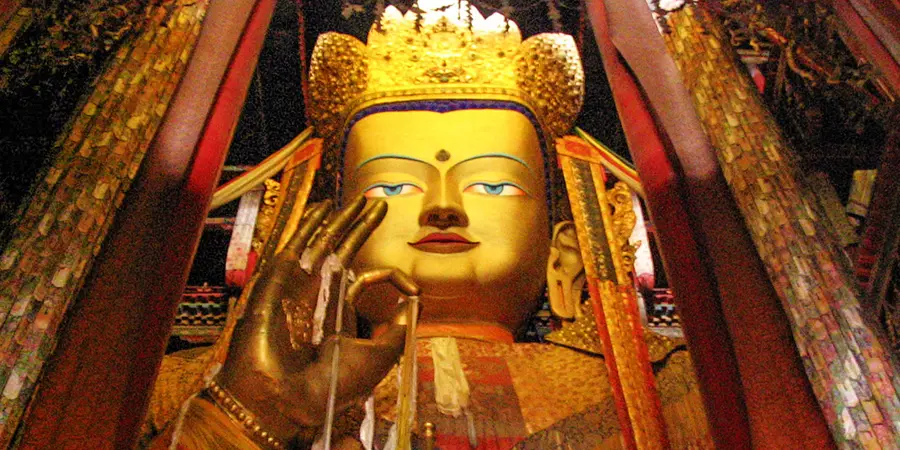 |
| The Buddha Statue in Tashilhunpo Monastery |
2. Qudengnima Glacier
In November, the lake at Qudengnima Glacier freezes, inviting you to walk to its heart to discover ice caves and cracks glowing with deep blue and emerald green, as well as ice towers with numerous stripes and weathered rocks below.
Upon reaching the deepest point at Qudengnima, the vast glacier confronts you, stretching out like a slumbering giant. As any noise fades away, you will find yourself enveloped in a silence so profound it makes you feel like you are at the very edge of the world.
3. Jilong Town
Jilong Town, bordered by Nepal and known as the "back garden of Mount Everest", offers a mild and humid climate even in winter, abundant with oxygen.
In Jilong Valley, where lush green forests and snowy mountains coexist, cross the chain bridge adorned with colorful prayer flags and get ready to be thrilled by the abyss on both sides, with Jilong River roaring below and gusts gently swaying the bridge.
After that, atop the Asia No.1 Snow Mountain Observation Deck, let the silver snowy mountains embrace you from every direction. It will also take your fatigue away as you stroll across the grasslands of Jilong and listen to the sound of cowbells tinkling as herds graze by.
In Jilong Town, you can also indulge in traditional Nepalese cuisine at Nepalese restaurants, such as curry chicken and mutton. Upon leaving, consider purchasing exquisite Nepalese handicrafts, like handwoven scarves and tapestries, as souvenirs or gifts for friends and family.
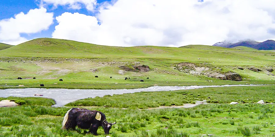 |
| The Grassland in Jilong Town |
- Last updated on Nov. 28, 2025 by Jally Zhang -